
Map and key for the Ballantrae Ophiolite Complex


Origins and Structure of the Ballantrae Ophiolite Complex
The area of land stretching between Girvan in the north to the River Stinchar to the south, and for several kilometres inland, has a geology which is markedly different to anything else in the South of Scotland. Exposed rock which is mainly found on the coast, shows a remarkable variety of types. Serpentinite is mingled with mixed beds of lava and sedimentary rock. The whole area is heavily and repeatedly faulted, giving a jumbled and confusing collection.
The knowledge of tectonic plate movement which developed during the mid twentieth century, has enabled a sounder interpretation of the Ballantrae Complex. It is now generally accepted that it was originally a slice of mantle rock and oceanic crust which has been uplifted (obducted) onto a land mass by tectonic processes to form what is known as an ophiolite.
The Ballantrae Complex can be broadly divided into five areas. There are two large masses of serpentinite, one in the north of the complex and the other to the south with some smaller areas of serpentinite between them. Separating the two main masses is a large extent of lavas, brecchias and sedimentary rocks which are known collectively as the Balcreuchan Group. There are also various intrusions of igneous rocks, mainly gabbro or dolerite but with some paler more felsic rocks on the Byne Hill ridge. Finally there is a small but important belt of metamorphic rocks at the southern end of the northern area of serpentinite.
While it is now clear that a process of obduction (uplifting) of mantle and oceanic crust created the Ballantrae ophiolite, there are still uncertainties about the exact process. It is agreed that as the Laurentian and Avalonian continents approached each other gradually causing the narrowing of the Iapetus Ocean, oceanic crust attached to Laurentia was subducted under oceanic crust attached to Avalonia giving rise to island arc volcanoes the remnants of which form the modern Lake District and Snowdonia. The two continents were eventually to collide causing the Caledonian Orogeny. The ensuing mountain building gave rise to the uplands of the Scottish Highlands, the Scandinavian mountains, and the Appalachian mountains in North America. One possible explanation of the Ballantrae obduction process is that as the two continents came closer together in the early Ordovician period (480-460 Ma), the subduction direction in the oceanic crust of the Iapetus Ocean reversed itself forcing a large slice of mantle and crust up onto the Laurentian continent.
Diagram showing a subduction zone & back-arc basin

The sequence of rocks in the Ballantrae Complex is derived from a slice extending from deep within the Earth’s mantle up to the top of oceanic crust at the sea bed. The mantle of the planet beneath oceanic crust lies below 20-50 km deep, and consists of peridotite. As the name suggests this is composed mainly of olivine (peridot) but usually with some pyroxene. The mantle rock exposed in the Ballantrae Complex was originally mainly harzburgite but with some dunite (see the ultrabasics composition diagram below) being composed mainly of olivine (Fe,Mg)2SiO4 with subsidiary orthopyroxene ((Fe,Mg)2Si2O6. It has now been altered to serpentinite. The mantle gradually gives way to oceanic crust through transitional rocks which grade into layers, at first of layered peridotite and then of layered gabbro, through a process of magma differentiation into more silica-rich composition.

The deepest layer of the oceanic crust consists of gabbro (plagioclase feldspar and pyroxene) which acts as the magma reservoir for the surface lavas. The gabbro feeds magma through a system of sheeted dykes. The magma issues at the ocean floor as basalt which when cooled by the water, forms polygonal segments called ‘pillows’. Above the pillow lava, sediments of mud, silt and sand build up. If the water is warm enough plankton and shellfish deposit enough material to form limestones. This sequence of rock was forced up to the surface in the Ballantrae Complex. However, in the process the tectonic forces were so great that the sequence was faulted and completely jumbled up. As a result some parts of the sequence appear to be missing.
The deepest layer of the oceanic crust consists of gabbro (plagioclase feldspar and pyroxene) which acts as the magma reservoir for the surface lavas. The gabbro feeds magma through a system of sheeted dykes. The magma issues at the ocean floor as basalt which when cooled by the water, forms polygonal segments called ‘pillows’. Above the pillow lava, sediments of mud, silt and sand build up. If the water is warm enough plankton and shellfish deposit enough material to form limestones. This sequence of rock was forced up to the surface in the Ballantrae Complex. However, in the process the tectonic forces were so great that the sequence was faulted and completely jumbled up. As a result some parts of the sequence appear to be missing.
The vulcanism which develops in the ocean falls into a number of types. Chemical and isotope analysis of the Ballantrae lavas and breccias suggest that all types are present, although there has been considerable disagreement amongst geologists about this.
Island arc vulcanism is one such type. At the present day it is well represented in Sicily and Southern Italy, some of the Greek islands, the Aleutian Islands, and in Indonesia and the Philippines. Subducting oceanic crust carries down with it considerable quantities of water which lowers the melting point of rock sufficient to allow the formation of magma. This may rise to the surface and form volcanic islands. The magma tends to have a lower temperature than other types. It is also likely to be more silica rich as it incorporates melt from the crust. It is also likely to contain hydrous minerals such as mica and amphibole.
Diagram showing three types of vulcanism

In some locations there is sufficient energy in the mantle to generate a mantle plume which forces its way to the surface as a ‘hot spot’. At the present time, Hawaii and Yellowstone are examples of mantle plumes. If the magma is erupted through oceanic crust, it will tend to have less silica, and may form olivine-rich basalts.
At some points, oceanic crust may start to extend and pull apart giving rise to mid-ocean ridges. As the crust weakens through extension hot mantle rock is able to force its way upwards to flood basalt over the sea floor. A modern day example of this is the mid-Atlantic ridge which has given rise to the vulcanism of Iceland. A possible scenario for this development in the ancient Iapetus Ocean was the process of back arc spreading – shown in the ‘Subduction and Back-arc Spreading’ diagram earlier.
All of these types of vulcanism are believed to have occurred in the Iapetus Ocean, and their remains may be found in the lavas of the Ballantrae Complex.
Rocks in the Ballantrae Complex
Serpentinite

Pinbain Hill from the shore near Pinbain Bridge with the higher, granite-topped Grey Hill behind.
The Northern Serpentinite mass extends from just north of Games Loup to the south-west of the complex up to Byne Hill in the north. It is broken up by various igneous intrusions including Bonney’s Dyke about 200m south of Pinbrain Bridge on the foreshore, and the major area of gabbro, diorite and leucotonalite on the Byne Hill to Grey Hill ridge. The serpentinite outcrops clearly in comparitively few places because it weathers readily to produce a subdued topography. The best outcrops at which to observe it are in the embayment at Pinbain Bridge and in the area south and east of Cairn Hill.
It is grey-green rather greasy looking rock deriving predominantly fron serpentinised olivine with blocks and nodules of brown bastite resulting from the serpentinisation of orthopyroxene. This points to an original ultrabasic peridotite magma predominantly of harzburgite with subsidiary dunite. The mineral olivine is the most easily altered when at high temperatures and in contact with water. The iron part of olivine (fayalite) is converted to magnetite (Fe3O4) and silica (SiO2); the magnesium part (forsterite) is converted to hydrated magnesium silicate (Mg3Si2O5(OH)4.

In places the serpentinite is criss-crossed with veins of fibrous chrysotile, and stained brick red by haematite which is a weathering product of both the parent olivine and orthopyroxene. Opaque black minerals, magnetite and chrome spinel, are abundant in places such as the Poundland Burn. At Pinbain Bridge in particular, the spinel is particularly rich in chromium and platinum.
At Carleton Fishery in the south-west of the mass there is evidence of foliation but it is unclear whether this is the result of metamorphosism or crystal segregation. Outcrops of harder less altered pyroxenite occur in places. These vary from coarse-grained rock in the north-west to finer material in the east of the mass. It is assumed that the pyroxene outcrops are magmatic segregations within the original peridotite rather than the product of high temperature and high pressure metamorphosism.
There are some small areas of serpentinite lying between the main northern and southern outcrops. These small areas are sandwiched in the middle of an extensive area of Balcreuchan volcano-sedimentary rocks. They seem to have been originally composed of harzburgite but have been heavily sheared by intense tectonic pressures.
The Southern Serpentinite belt extends from Bennane Lea on the coast in the south-west to Fell Hill in the east. There are good exposures on Bennane Lea itself but also on Balhamie, Breaker and Clauchanton Hills. As in the Northern Serpentinite belt, the original peridotite seems to have been predominantly harzburgite with subsidiary dunite. In the south of the mass towards the Stinchar Valley it appears to have been increasingly wehrlite. The bed of the River Stinchar south-east of Knockdolian is predominantly composed of pyroxenite suggesting an original ultrabasic lherzolitic composition. Interestingly, between Breaker and Knockdaw Hills there is a zone of olivine gabbro (troctolite) corresponding to the transition zone between the mantle and the lower oceanic crust.
Metamorphic Rocks
A narrow band of metamorphosed pelites crop out at the southern edge of the Northern Serpentinite belt at Balsalloch and Carleton Hills, on the Lendal Water by Staid Bridge, and on the hillside north west of Knocklaugh. These consist of a band of slaty greenschist facies rock followed by an upper narrow band of tougher amphibolite. Green schist which derives its colour from the minerals epidote and chlorite, is formed from pelitic rock at relatively low temperatures and pressures ranging between 280oC and 480oC and 1-8 kb (kilobars). Amphibolite containing large amounts of hornblende, is formed at higher temperatures (500oC-750oC) and greater pressures (2-12kb). The fact that these bands of rock occupy such a narrow width means that, given the wide difference in temperatures and pressures of formation, they cannot have been formed in close proximity at the same time. Radiometric dating from Sm (Samarium), Nd (Neodymium), K and Ar (Argon) confirms this, giving a date for the green schists of 478 ± 8 Ma, and the amphibolite at 505 ± 11 Ma. The apparent reversal of expected order between green schist and amphibolite is characteristic of the metamorphic ‘sole’ of a magmatic body which has been obducted onto continental plate.
An altogether rarer metamorphic rock which does occur sparingly in the Ballantrae Complex, is blue schist. This is grey-blue rock deriving its colour from blue amphiboles such as crossite and glaucophane. It is formed at relatively low temperatures (200C-500C) but high pressure (7-13kbBa). This unusual combination of circumstances accounts for its relative rarity. It is found sparingly in the meta-basalts of the central Balcreuchan zone near Knockormal Farm, and in the melange deposits around Currairie and at Pinbain Bridge. Its presence suggests that the central area of the Ballantrae Complex was subjected to intense shear stresses. An interesting anomaly about the Knockormal blue schists is the presence close by of garnet-pyroxenite (originally misclassified as eclogite). It is not clear whether the garnet-pyroxenite is an erratic, or a result of magmatic segregation within the peridotite, or very high temperature and pressure metamorphosism. Whatever the case it could only have been formed or survived at temperatures and pressures completely different from those forming the blue schist, and so must have been juxtaposed with the blue schist by powerful tectonic forces.
In the northern part of the Ballantrae Complex, the Balcreuchan rocks are best seen between Pinbain Bridge and through Slockenray (NX139918) to Kennedy’s Pass. Pillow lavas which may be either aphyric or porphyritic, may be seen here. Some of the rocks are heavily brecciated. The sedimentary deposits which are mixed with the volcanic have revealed a graptolite fossil record which gives an early Arenig age (475-480 Ma). One of the most interesting features is the melange deposit at Pinbain Bridge which contains an exotic suite of different rocks including blue schist, greywacke and green schist.

There has been much disagreement about the origin of the lavas; the debate swung between ocean island and island arc origin but has tended in recent years to emphasise within plate formation through back arc spreading.
In the central area, there are good examples of pillow lava and breccia on the south flank of Balsalloch and Carleton Hills. There is further evidence of melange deposits in the stream beds at Currairie with, as at Pinbain Bridge, a wide variety of rock types. As in the northern area, the sedimentary rocks at Games Loup can be dated at early Arenig from the graptolite fauna. An interesting complication for understanding the geology is the presence of meta-basalts near Knockormal Farm, which have been transformed wholly or partially into blue schists. These and the so-called ‘eclogite’ nearby are dealt with in the section on metamorphic rocks. There has been considerable debate again about the origin of the lavas, whether island arc or ocean island. Modern views incline towards primitive island arc lava.
Balcreuchan rocks in the Southern area are best seen at Bennane Lea, and between Balcreuchan Port and Port Vad. Some of the lavas here are particularly rich in Si and Mg, and so are classified as boninites. There is again uncertainty about the origins, whether within plate or island arc.
Magmatic Intrusive rocks
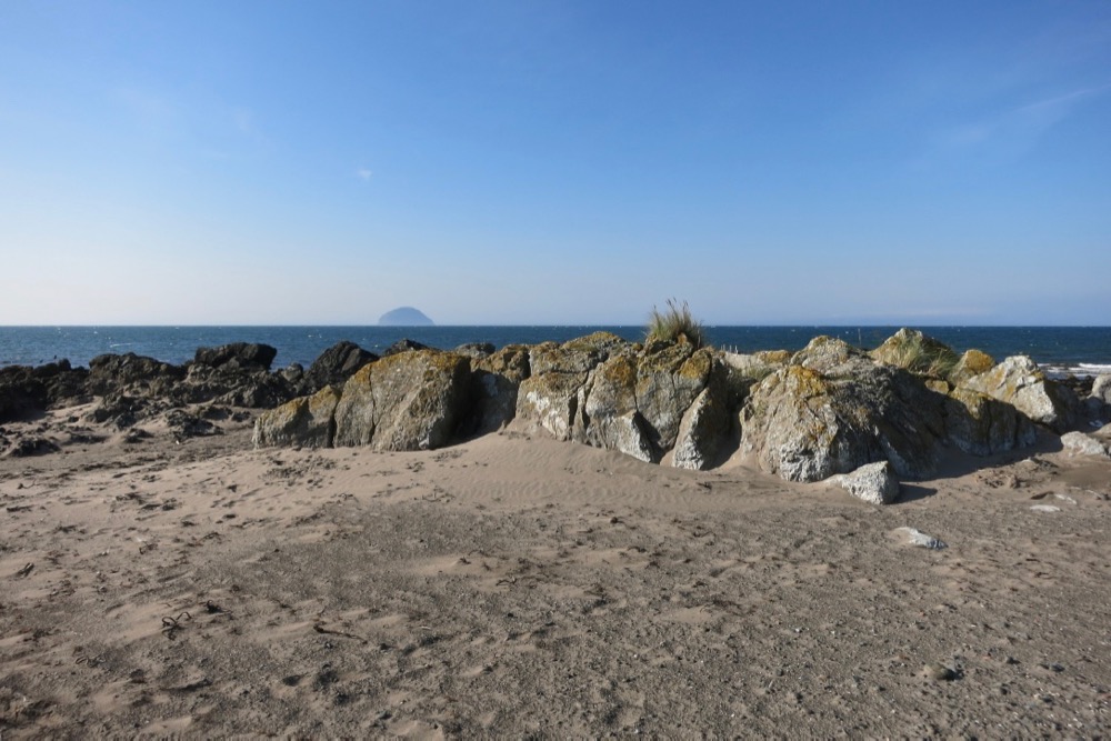
A spectacularly pegmatitic gabbro with Ailsa Craig, a volcanic plug, in the distance.
There are some obvious examples of intrusive igneous rock in the Ballantrae Complex. The largest area forms the bulk of Byne, Cairn and Grey Hills. The central core, well exposed at the top of Byne Hill consists of leucotonalite. This is a white to yellow rock consisting almost entirely of quartz and plagioclase feldspar. This grades outwards through diorite into gabbro at the margin with the serpentinite. It is chilled against the serpentinite indicating that it was emplaced hot after the ultrabasic magma had cooled. Dating of the Byne Hill zircons gives an age for the intrusion of about 483 Ma. The sequence of rocks can be best seen on the south-east flank of Byne Hill. There has been some debate whether the leucotonalite (originally classified as trondhjemite) is magmatic in origin or the result of metasomatism.
Bonney’s Dyke forms a striking black and white intrusion on the foreshore about 200m south of Pinbain Bridge. It consists of pegmatitic gabbro in which the feldspar is largely altered to pectolite, pumpellyite and prehnite. It does not show a chilled margin against the serpentinite so it must have been emplaced when both were hot. There are further dolerite dykes on the foreshore south of Bonney’s Dyke.
Gabbro intrusions occur between Troax and Knockormal Farms. It also forms the foundation of the harbour wall at Ballantrae. There is an extensive area of gabbro sheets and dykes close to Millenderdale. It is not clear whether these represent layered gabbro or sheeted dykes (see diagram of ideal ophiolite sequence) or a combination of both.
Retrograde metamorphosism is an important alteration factor in many of the Ballantrae gabbros and dolerites. This occurs when existing rocks are subjected to pressures and temperatures which are too low to maintain the stability of their existing mineral content. As a result many of the Ballantrae dolerites and gabbros have had their pyroxenes degraded to amphibole. Feldspars may degrade to an array of minerals such as calcite, pumpellyite, prehnite and pectolite. The degraded gabbros and dolerites in the vicinity of Millenderdale have been classified as ‘beerbachites’ on account of this retrograde metamorphism.
References
P. Stone, 2014, A Review of Geological Origins and Relationships in the Ballantrae Complex, SW Scotland, Scottish Journal of Geology, Volume 50, 1-25.,
P. Stone (et. al.), 2012, British Regional Geology, South of Scotland 4th edition, British Geological Society, Nottingham.
G.J.H. Oliver, P. Stone & B.J. Bluck, 2003, The Ballantrae Complex and Southern Uplands Terrain appearing in The Geology of Scotland ed. N.H. Trewin Geological Society.
Lawson, J.D. and Weedon, D.S. (editors), 1992, Geological excursions around Glasgow & Girvan. Glasgow : Geological Society of Glasgow.
British Geological Society Online Maps
https://mapapps.bgs.ac.uk/geologyofbritain/home.html